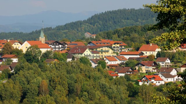
Rattenberg
Das familiengeführte 4 Sterne Wellness Hotel „Posthotel Rattenberg“ liegt direkt im Bayerischen Wald nahe St. Englmar und ist besonders wegen des breiten Angebotes an Wellnessanwendungen sowie hauseigenen Saunen und großzügigem Schwimmbad sehr beliebt. Gerne kümmern wir uns um Ihre Gesundheit und tragen dafür Sorge, dass Sie entspannt und erholt aus Ihrem Urlaub zurückkehren.
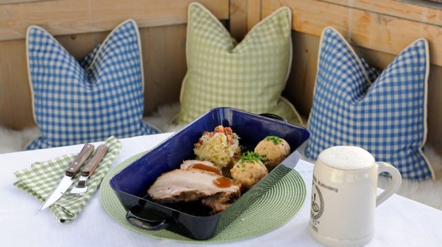
Nicht nur als Wanderhotel sind wir eine der schönsten Adressen Niederbayerns, sondern auch auf der Suche nach einem Tagungshotel, sind Sie bei uns genau richtig. Dank 3/4 Persion mit je nach Wochentag 4-Gang-Wahlmenü, Kulinarischem 5-Gang-Verwöhnmenü oder Themenbuffetabend, Nachmittagsbrotzeit, Kaffee und Kuchen ist auch für das leibliche Wohl gesorgt.
Angebote


Service
Wanderhotel im Bayerischen Wald
Der Perfekte
Wanderurlaub
Entdecken Sie die Wanderregion Bayerischer Wald mit dem Posthotel Rattenberg. Zahlreiche Wanderangebote warten auf Sie.
Winterurlaub in Bayern
Skiurlaub
Winter und Schnee im Bayerischen Wald
Winterspaß für Groß und Klein. Genießen Sie eine wundervolle Zeit im winterlichen Bayerischen Wald und dem Posthotel Rattenberg.
Tagungshotel Bayerischer Wald
Tagungen
im Bayerischen Wald
Halten Sie Tagungen, Seminare oder Veranstaltungen im Posthotel Rattenberg. Das besondere Event im Bayerischen Wald.
Tagungshotel Bayerischer Wald
Waldsommer
im Bayerischen Wald
3 Übernachtungen plus 3/4-Verwöhnpension-Inklusivleistungen + 25€ Wellness Gutschein


Unsere Zimmer
Liebevoll und komfortabel eingerichtete Zimmer lassen Sie im Posthotel Rattenberg auch in Ihren „eigenen vier Wänden“ zur Ruhe finden. Je nach Bedarf können Sie zwischen verschiedenen Kategorien wählen

Wellnesshotel Posthotel Rattenberg - Bayerischer Wald
Hier gibt es zahlreiche Wellnessangebote zum Wohlfühlen in einem völlig neu gestalteten Wellnessbereich. Genießen Sie die Stille und Entspannen Sie im Wellnesshotel Bayerischer Wald, denn bei uns können Sie inmitten der Natur sanft die Reserven wieder aufladen und neue Kraft schöpfen.
Im Wellnesshotel Bayerischer Wald erwarten Sie 49 liebevoll eingerichtete Zimmer in denen man wunderbar zur Ruhe kommen kann. Tagen Sie doch in den modernen Tagungsräumen unseres 4-Sterne Wellnesshotels in Bayern und machen Sie auch Ihre Geschäftsreise zum Erholungs-Erlebnis.
Auch die ausgezeichnete Kulinarik im Bayerischen Wald spricht für sich. Bei uns können Sie abwechslungsreiche Menüs mit typischen Speisen aus der Region Bayerischer Wald probieren und bei unserem wöchentlichen Buffetabend kulinarische Hochgenüsse erleben. Dabei wählen wir die Zutaten der Speisen gezielt aus dem Anbau der Umgebung aus und überraschen Sie mit immer neuen köstlichen Kreationen.
Nicht nur als Wellnesshotel stehen wir für eine der schönsten Adressen Niederbayerns, sondern auch als gemütliches Wanderhotel . Viele Wanderer kommen extra zu uns in den Bayerischen Wald, um die zahlreichen Wanderwege mit unterschiedlichen Längen- und Schwierigkeitsgraden zu erkunden und die Region Bayerns näher kennenzulernen.
Entfliehen Sie dem Alltag und entspannen Sie sich bei unseren Verwöhn- und Entspannungsprogrammen. Nutzen Sie die zahlreichen Wellnessangebote und wählen Sie eine unserer 15 wohltuenden Massagen aus. Hierbei kommen Sie ganz auf Ihre Kosten. Sowohl die Anti-Stress Massagen als auch die vitalisierenden Bürsten-Massagen werden Ihren Körper und Geist wieder in Form bringen. Als besonderer Insider-Tipp gilt unser Cleopatrabad, bei dem sich Ihre Haut ganz von alleine regeneriert und seidig weich wird.
Für Familien mit Kindern bieten wir besondere Testangebote an. Während Sie sich entspannen haben Ihre Kleinen bei uns die Möglichkeit, bei Schnupperangeboten Gefallen an den umfangreichen Wellnessprogrammen zu finden. Wir bieten unter anderem Fußmassagen für die müden kleinen Füße unserer gestressten Gäste an oder aber ein kleines Maniküre Programm mit Fingernägel lackieren und Fußpflege. So fühlen sich auch unsere kleinen Gäste ganz groß.
Haben Sie schon mal den verschneiten Winter in St. Englmar im Bayerischen Wald verbracht? Falls nicht, dann ist es höchste Zeit.
Genießen Sie die Ausblicke auf die verschneite Landschaft Bayerns und kommen Sie bei uns zur Ruhe. In St. Englmar können Sie lange Schneespaziergänge machen und Ihrem Körper durch die reine Luft etwas Gutes tun. Vor unserem gemütlichen Kamin haben Sie die Möglichkeit, sich bei einer heißen Schokolade und einem leckeren Essen wieder zu stärken und aufzuwärmen. Nach einem kalten Wintertag wirken besonders unsere Saunen Wunder. Durch die angenehme Wärme kommt der Körper wieder zur Ruhe und entspannt sich zunehmend.
Probieren Sie unsere Angebote aus und erholen Sie sich im uns. Google+